


Wakefield Precinct 4, Middlesex County, Massachusetts
About
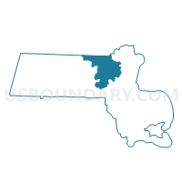
Outline

Summary
| Unique Area Identifier | 594743 |
| Name | Wakefield Precinct 4 |
| County | Middlesex County |
| State | Massachusetts |
| Area (square miles) | 1.11 |
| Land Area (square miles) | 0.98 |
| Water Area (square miles) | 0.12 |
| % of Land Area | 88.82 |
| % of Water Area | 11.18 |
| Latitude of the Internal Point | 42.47923490 |
| Longtitude of the Internal Point | -71.06784990 |
Maps


Graphs
Select a template below for downloading or customizing gragh for Wakefield Precinct 4, Middlesex County, Massachusetts


Neighbors
Neighoring Voting District (by Name) Neighboring Voting District on the Map
- Melrose Ward 1 Precinct 1, Middlesex County, MA
- Melrose Ward 1 Precinct 2, Middlesex County, MA
- Melrose Ward 2 Precinct 1, Middlesex County, MA
- Saugus Precinct 9, Essex County, MA
- Stoneham Precinct 5, Middlesex County, MA
- Stoneham Precinct 7, Middlesex County, MA
- Wakefield Precinct 3, Middlesex County, MA
- Wakefield Precinct 5, Middlesex County, MA
Top 10 Neighboring County Subdivision (by Population) Neighboring County Subdivision on the Map
- Melrose city, Middlesex County, MA (26,983)
- Saugus town, Essex County, MA (26,628)
- Wakefield town, Middlesex County, MA (24,932)
- Stoneham town, Middlesex County, MA (21,437)
Top 10 Neighboring Place (by Population) Neighboring Place on the Map
- Melrose city, MA (26,983)
- Saugus CDP, MA (26,628)
- Wakefield CDP, MA (24,932)
- Stoneham CDP, MA (21,437)
Top 10 Neighboring Unified School District (by Population) Neighboring Unified School District on the Map
- Melrose School District, MA (26,983)
- Saugus School District, MA (26,628)
- Wakefield School District, MA (24,932)
- Stoneham School District, MA (21,437)
Top 10 Neighboring State Legislative District Lower Chamber (by Population) Neighboring State Legislative District Lower Chamber on the Map
- Ninth Essex District, MA (41,963)
- Thirty-Second Middlesex District, MA (41,266)
- Thirty-First Middlesex District, MA (39,661)
Top 10 Neighboring State Legislative District Upper Chamber (by Population) Neighboring State Legislative District Upper Chamber on the Map
Top 10 Neighboring 111th Congressional District (by Population) Neighboring 111th Congressional District on the Map
Top 10 Neighboring Census Tract (by Population) Neighboring Census Tract on the Map
- Census Tract 3362, Middlesex County, MA (6,142)
- Census Tract 2084, Essex County, MA (5,745)
- Census Tract 3351, Middlesex County, MA (5,728)
- Census Tract 3352, Middlesex County, MA (5,637)
- Census Tract 3361, Middlesex County, MA (5,360)
- Census Tract 3354, Middlesex County, MA (5,094)
- Census Tract 3371.02, Middlesex County, MA (5,042)
- Census Tract 3353.01, Middlesex County, MA (3,852)
- Census Tract 3371.01, Middlesex County, MA (3,095)